|
WEN Lab's GEOSPATIAL Gallery: 2006-2016
1. Diffusion Patterns | 2. Epidemic Dynamics | 3. Exposure
Risk | 4. Vector Surveillance | 5. Health Care Utilization |
6. Mobility Studies
| 7. Urban Congestion | 8. Environmental Sensing | 9.
Population Maps | 10. Natural
Resource |
1. Diffusion Patterns

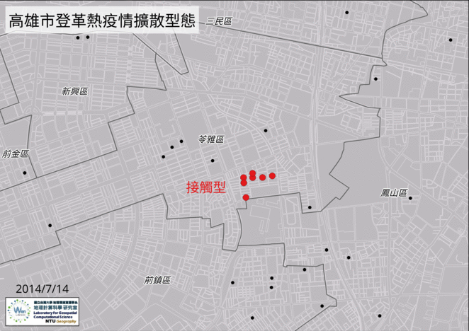 |
Diffusion is defined in
Oxford English Dictionary as “to
disperse or be dispersed from a center; to spread widely, disseminate.”
Geographers
categorized the structures of spatial diffusion into four types, which
can represent the characteristics of the spreading phenomenon. It
includes that expansion diffusion is the process which
a phenomenon of interest spreading from one place to another;
relocation diffusion is the process which the a phenomenon of
interest leaving the areas where they originated and moving to another
new areas; contagious diffusion is the process which
strongly influenced by distance and hierarchical
diffusion is the process which a phenomenon of interest spreading
through an ordered sequence of classes or places. |
 |
 |
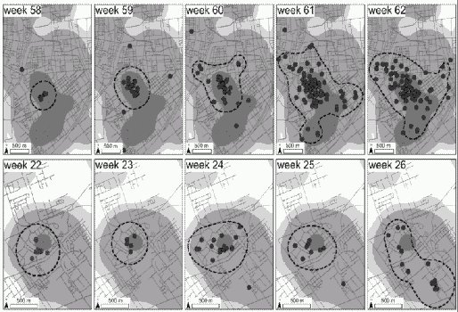
Summary: This study proposed an
innovative methodology that considers only the spatial-temporal
relationships of illness onsets, combining exploratory spatial analysis
and network topological indicators, degree centrality and network
clustering coefficient, to identify space-time clusters, track possible
sources of an epidemic and measure transmission risk of an individual.
Furthering Reading:
1. Two Clustering
Diffusion Patterns Identified from the 2001-2003 Dengue Epidemic. American Journal of Tropical Medicine & Hygiene 79(3): 344–352.
link
2. Population Movement and Vector-borne Disease Transmission:
Differentiating Spatial-temporal Diffusion Patterns of
Commuting and Non-commuting Dengue Cases. Annals of the Association of American Geographers 102(5):
1026-1037. link
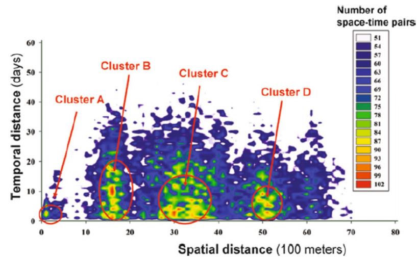
3.
Analyzing the Patterns of Space-Time Distances for
Tracking the Diffusion of an Epidemic,
In
Kwan MP, Richardson
D, Wang D and Zhou C (Eds.). Space-Time
Integration in Geography
and GIScience,
Dordrecht: Springer. (ISBN:
978-94-017-9204-2) link |
2. Epidemic Dynamics
LINK
|
Simulating the Spread of Influenza A (H1N1)
in Taiwan under the scenario of Taipei outbreak.
Summary: Our proposed framework,
Multilayer Epidemic Dynamics Simulator (MEDSim), has four contact
structures: within age group, between age groups, daily commute, and
nationwide interaction. We simulated outbreak locations and intervention
scenarios for the 2009 swine-origin influenza A (H1N1) epidemic. Our
results indicate that lower transmission rates and earlier intervention
activation times did not reduce total numbers of infected cases, but did
delay peak times.
Furthering Reading:
Integrating Epidemic Dynamics with Daily
Commuting Networks: Building a Multilayer Framework to Assess Influenza
A (H1N1) Intervention Policies.
Simulation: Transactions of The Society for Modeling and Simulation
International 87(5): 385-405.
link |
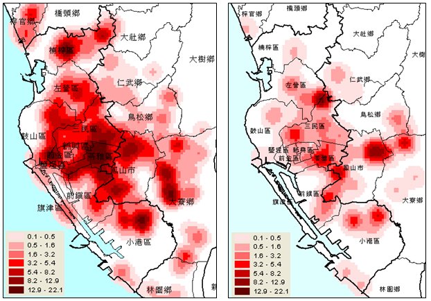
3. Risk of Exposure to Dengue
 |
 |
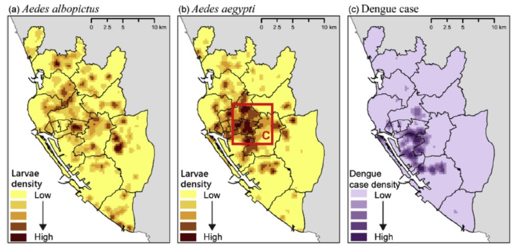
Summary:
This study clarifies the geographic effects of
crowd gathering places on the frequency of dengue vector for assessing
the spatial risk of exposure to dengue in Kaohsiung City, Taiwan. Our
results indicated that people closer to crowd-gathering places have a
higher frequency of contact with Ae. aegypti than with Ae.
albopictus larvae. The dengue risk is caused by the human-Aedes
aegypti contacts concentrated around city centers, while the risk
caused by the human-Aedes albopictus contacts is distributed
around the city boundary.
Furthering Reading:
Incorporating the Human-Aedes Mosquito
Interactions into Measuring the Spatial Risk of
Urban Dengue Fever, Applied
Geography 62:256-266. link |
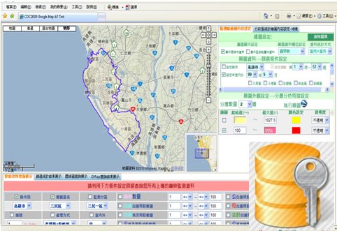
4. Dengue Vector Surveillance
 |
 |
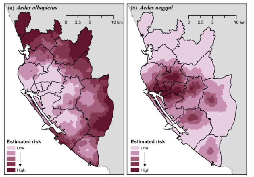
Summary: This
research evaluated the spatiotemporal distribution of dengue vectors by
a human population stratified ovitrap survey. We demonstrated the
potential intensity of dengue transmission spatiotemporally in the high
epidemic areas. We analyzed the temporal patterns of vector abundances,
compared the levels of vector aggregation indoors with outdoors, and
assess the vector concentration tendency around residential centers and
administration edges form June 2010 to June 2011.
Furthering Reading:
1.
A Dengue Vector Surveillance by Human Population-stratified Ovitrap
Survey for Aedes (Diptera: Culicidae) Adult and Egg Collections
in High Dengue-risk Areas of Taiwan, Journal
of Medical Entomology 50(2):261-269. link
2.
The Spatio-temporal Characteristics of Potential Dengue Risk Assessed
by Aedes aegypti and Aedes albopictus in High-epidemic
Areas, Stoch
Environ Res Risk Assess 30(8):
2057–2066. link
|
5. Health Care Utilization
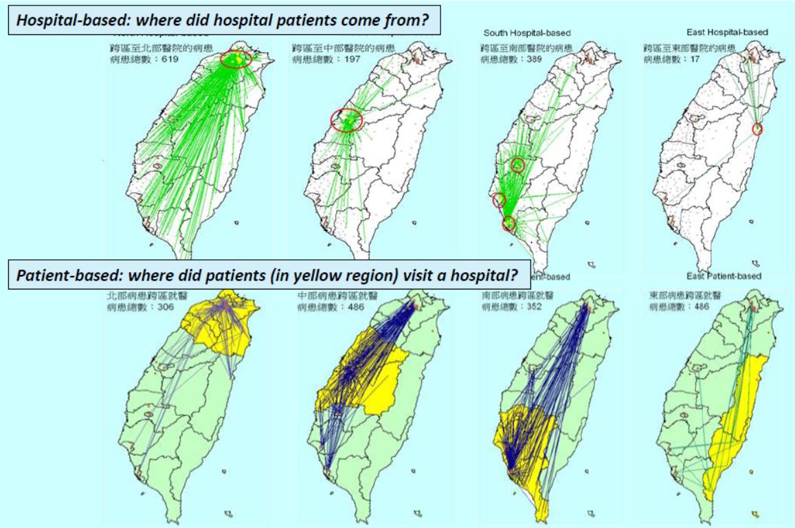
Summary: Employing a GIS-based accessibility approach, this
study found that medical resources within-district and distance to
cross-district hospitals significantly affected patients’
hospital-seeking behavior. By identifying the non-linear relationship
between accessibility to hospitals and patients’ cross-district
hospital-seeking, our results showed the importance of incorporating
spatial inequality into the planning for the provision and utilization
of health care.
Furthering Reading:
1. Profiling the Patient Flow for Seeking Healthcare in Taiwan: using
Gravity Modeling to Investigate the Influences of Travel Distance and
Healthcare Resources, Taiwan
Journal of Public Health 35(2):
136-151. pdf | link
2. Using Geographic Information Systems (GIS) to
Identify the Association between Geographic Accessibility and
Hospital-seeking Behavior by Hepatocellular Carcinoma Patients in
Taiwan. Taiwan
Journal of Public Health 28(6):
517-529. pdf
|
6. Mobility Studies
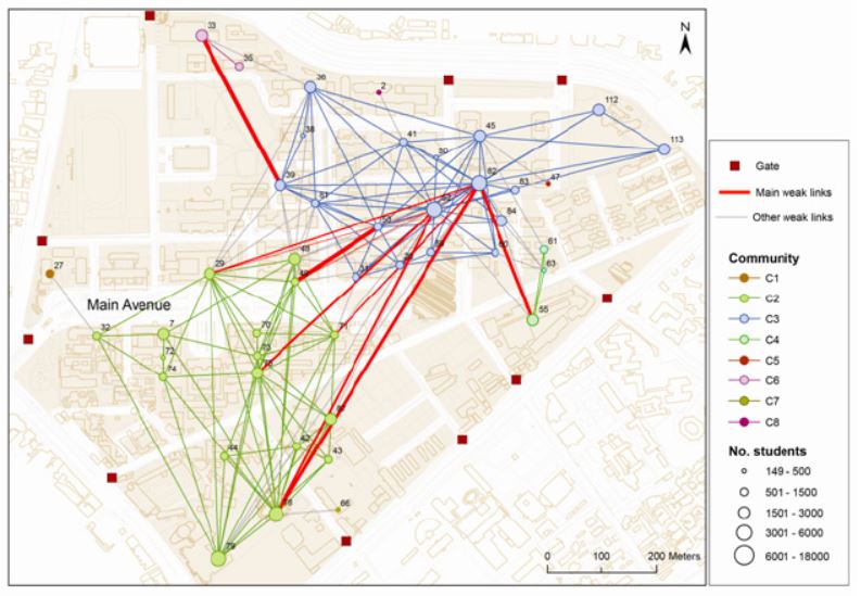
Summary:
We proposed geographically modified PageRank algorithms that incorporate geographic considerations into
PageRank algorithms to identify the spatial concentration of human
movement in a geospatial network. Our findings indicate the proposed
algorithms more effectively capture the spatial locations where people
reside than traditional commonly-used network metrics. In comparing
location attractiveness and distance decay, we conclude that the
concentration of human movement is largely determined by the distance
decay. This implies that geographic proximity remains a key factor in
human mobility.
Furthering Reading:
1.
Incorporation of Spatial
Interactions in Location Networks to Identify Critical Geo-Referenced
Routes for
Assessing
Disease Control Measures on a Large-Scale Campus, Int
J Environ Res Public Health 12,
4170-4184. link
2.
Geographically Modified PageRank Algorithms: Identifying the Spatial
Concentration of Human Movement in
a Geospatial Network, PLOS
ONE 10(10):
e0139509. link |
7. Urban Congestion
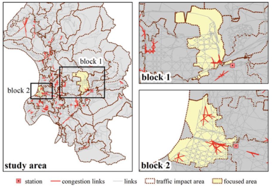
Summary:
We proposed an analytical procedure of ranking
algorithm, the Flow-based PageRank (FBPR), for investigating the traffic
flow concentration, complexity of street network structure and traffic
impact areas. Our results indicate that only relying on the topological
structure of the street network, this framework could identify the
Central Business Districts (CBD), and the areas proximate to the
stations of the combination of MRT and train railway systems are prone
to traffic congestion. Meanwhile, the delineation of traffic impact
areas could be spatially targeted at priorities of traffic improvement
for city planners.
Furthering Reading:
1. Understanding the Topological Characteristics
and Flow Complexity of Urban Traffic Congestion, PHYSICA A:
Statistical Mechanics and Its Applications 473:166-177.
link
2.
Link Structure Analysis of
Urban Street Networks for Delineating Traffic Impact Areas.
In
Essaaidi and Nemiche
(Eds.), Advances
in Complex Societal, Environmental and Engineered Systems,
Springer Series: Nonlinear
Systems and Complexity, Springer. (ISBN
978-3-319-46164-9) link |
8. Wireless Geo-sensors for Environmental Sensing
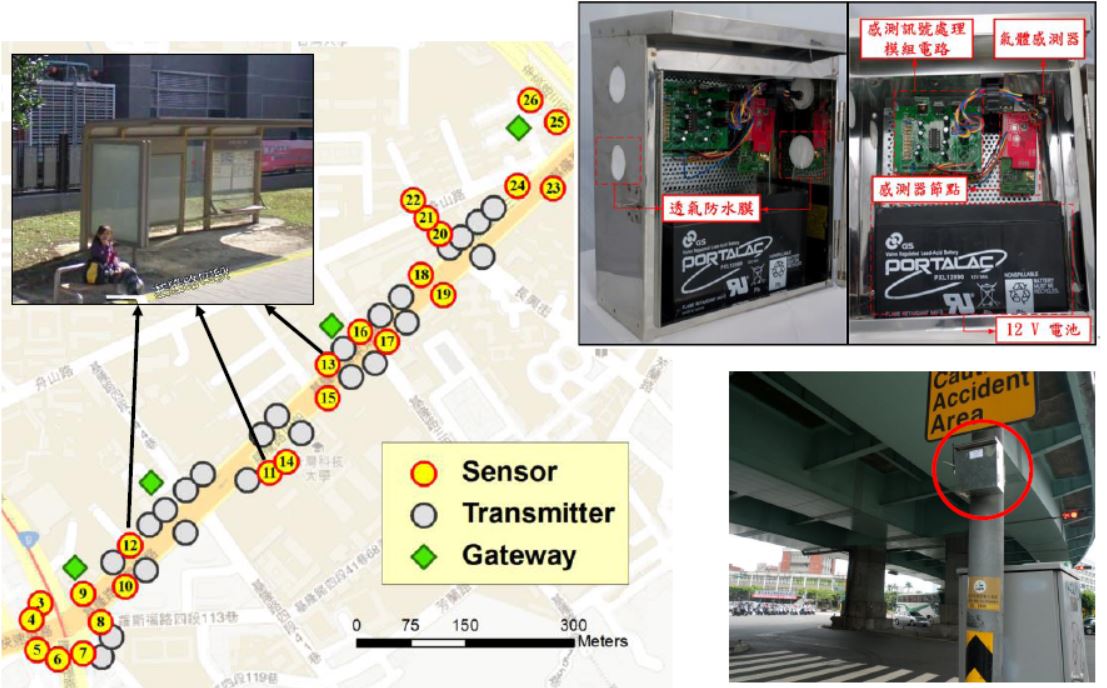
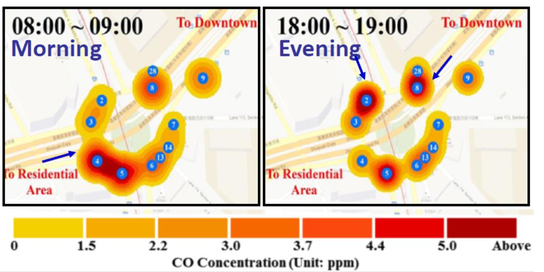
Summary: By
deploying wireless sensors on crossroads and main roads, this study
established a pilot framework for a wireless sensor network (WSN)-based
real-time monitoring system to understand street-level spatial-temporal
changes of carbon monoxide (CO) in urban settings. The system consists
of two major components. The first component is the deployment of
wireless sensors. The other component is a map-based monitoring platform
for sensor data visualization and manipulation in time and space. Using
intensive real-time street-level monitoring framework, we compared the
spatial-temporal patterns of air pollution in different time periods.
Furthering Reading:
Monitoring Street-level Spatial-Temporal Variations of Carbon Monoxide in
Urban Settings Using a
Wireless Sensor Network (WSN) Framework, Int
J Environ Res Public Health 10(12),
6380-6396. link |
9. Population Maps
The Census Atlas of Taiwan (1956-2010)
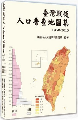
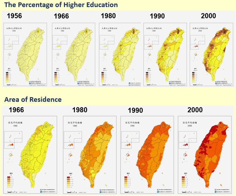
Summary:
Taiwan's population structure had changed rapidly after the war.
Events such as baby boom during retrocession period and the low birth
rate in contemporary era had all dramatically changed the population
structure in Taiwan. In order to picture the context of population
change in Taiwan, we paid efforts to digitalize the census data released
on 1956 and 1966 and publish the Census Atlas of Taiwan (1956-2010).
We also established
e-Atlas: Taiwan Census Explorer
1956-2010 for publishing interactive maps
and charts on the
Web.
Furthering Reading:
1. The Census Atlas of Taiwan
(1956-2010) , Taipei: NTU Population and Gender Studies Center & Dept.
of Geography, 305 pages. (ISBN: 978-986-03-5765-3)
link
2.
e-Atlas: Taiwan Census Explorer 1956-2010
(Chinese/English)
link |
10. Natural Resources
Biomass Energy Landscape
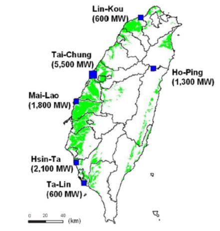
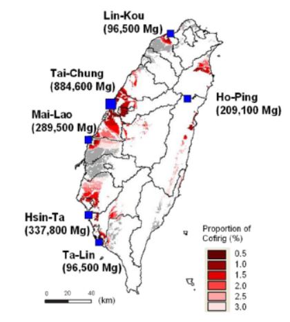
Summary: We
established a linear complementarity model to simulate the power market
equilibrium with cofiring systems in Taiwan. A GIS-based analysis was
then used to analyze the geospatial relationships between paddy rice
farms and power plants to assess potential biomass for straw-power
generation. The above maps illustrate paddy rice straw and the locations
of power plants. The results showed spatial distribution of rice straw
collection for various cofiring scenarios and CO2 emissions reductions
of these power
plants.
Furthering Reading:
GIS-based Biomass Resource Utilization for
Rice Straw Co-firing in the Taiwanese Power Market,
Energy 55:354-360 link |
Water
Resource Management
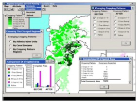
Summary: This
study proposed a novel spatial scenario-based
planning framework, with a database, model base, and scenario-setting
modules, to generate flexible spatial planning scenarios for improving
irrigation water-demand planning. A prototype of the
proposed scenario-based framework is implemented on a geographic
information system platform to assist in spatial decision making. Demand
planning during a drought period for the Chia-Nan irrigation command
area, the largest one in Taiwan, is adopted as a case study to
demonstrate the proposed framework for spatial scenario analysis.
Furthering Reading:
Analysis of Spatial Scenarios Aiding Decision-Making for
Regional Irrigation Water-Demand
Planning, Journal
of Irrigation and Drainage Engineering-ASCE 133(5): 455-467. link |
|