¤
(1)
To provide the most appropriate
multi-scale spatiotemporal modeling and
scale impact assessment tools, policy
instruments and national responsibility
assessment. To foster our capacity for
bird diversity conservation across
spatial and temporal scales and
disseminate them to a wide range of
users in Asia, including Taiwan.
(2)
To perform scale-dependent
impacts analysis (based on species
traits)
(3)
To
develop methods for upscaling and
downscaling
(4)
To devise methods for multi-scale
spatiotemporal modeling and mapping
(5)
To develop national responsibility
assessment and tools
(6)
To develop analysis methods and achieve
policy integration for effective Taiwan
or Asia bird diversity conservation
across scales
(7)
To translate and integrate results into
SCALES project for a support tool kit
online supporting sustainable
conservation across scales
(8)
Disseminate the results to relevant individuals
Top
Work Packages
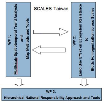
¨Work
package 1:
WP_TW1: Multi-scale Spatiotemporal Trend
Analysis and Map Methods and Tools
¤
¨Work
package 2:
WP_TW2:
Multi-scale Effects of Land-use on
Biotic Processes
¤
¨Work
package 3:
WP_TW3: Hierarchical National
Responsibility Approach and Tools
Top
¤
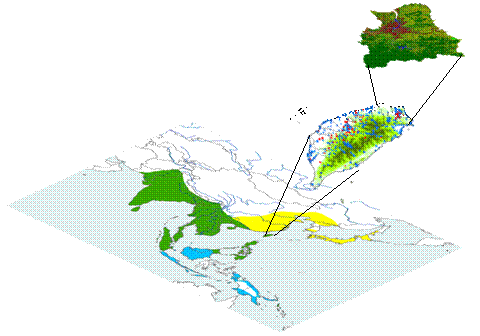
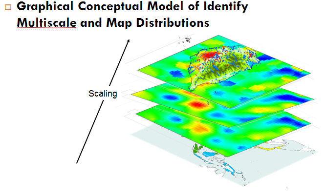
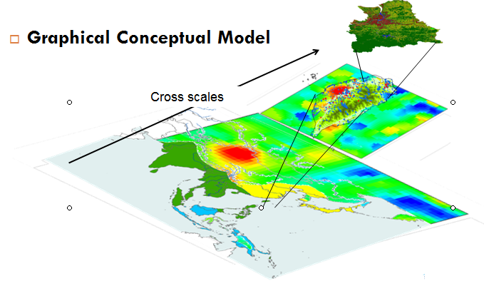
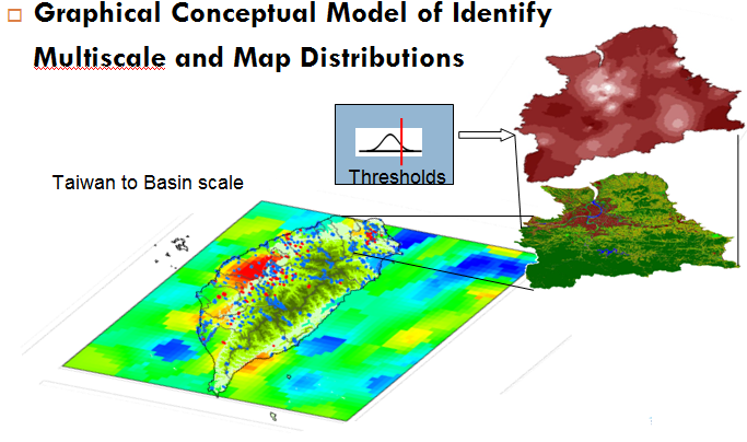
Conceptual Models:
Top
Members:
¨National
Taiwan University
¤Department
of Bioenvironmental Systems Engineering
nMeng-Ing
Li, Postdoctoral Fellow
nYen-Lan
Liu, Ph.D. Student (Department of Geography)
nChiun-Wei
Hung, Ph.D. Student
n
Master
Students
Department
of Forestry and Resource
Conservation
¨Chinese
Culture University
¤Department
of Landscape
Architecture
n
Advisory Board Member:
¨Kainan
University
¤Office
of International
Programs and
Services
nKang-Tsung
Chang, Ph.D.
Professor of
Tourism
&Hospitality,
Professor
Emeritus,
University of
Idaho (USA)
National Taiwan
University
Institute of Ecology
and Evolutionary Biology
n
Chinese Cultural University
College of Environmental Design
Monica Kuo, Dean
Top
Expected Results:
¨
WP 1: Multi-scale
Spatiotemporal Trend Analysis and Map Methods and Tools
¤
Develop multi-scale
identification methods
¤
Identify multiple
scales of bird diversity
¤
Develop multi-scale AIK
spatiotemporal analysis and Models
¤
Map multi-scale
distribution of Bird diversity and variations at various
scales
¤
Develop multi-scale
analysis and map tools
¤
Share and exchange
results with the SCALES team
¨
WP 2:
Land Use Effect on Ecosystem Resistance to Biotic
Homogenization across Scales
¤
A model with factors
affecting ecosystem’s resistance to avian homogenization
at county, regional, city, habitat scales.
¤
Conservation planning
guidelines for restraining biotic homogenization in
focal area.
¤
Design guidelines for
increasing native species and constraining
aggressive/invasive species in focal areas.
¤
Identify driving
factors of impacting bird diversity at various scales
¤
Delineate impacts of
land use and factors on bird diversity at various scales
¤
Share and exchange
results with the SCALES team
¨
WP 3: Hierarchical
National Responsibility Approach and Tools
¤
Provide a list of
national responsibility of species conservation by using
the range-based approach (Schmeller et al. 2008b)
¤
Compare the list of
national responsibility with the current endangerment
level given by IUCN Red List
¤
Compare the list of
national responsibility with the current protected
species list in Taiwan
¤
Identify candidate
species for future considerations of legal protection in
Taiwan
¤
Develop Hierarchical
national responsibility System Model and Tools
¤
Share and exchange
results with the SCALES team
Top
Selected publications
-
Chiang, L.-C., Y.-P.
Lin*, T. Huang, Y.-L. Liu, D. Schmeller, P.H.
Verburg, Y.-L.Liu, T.-S. Ding, 2014, Simulation
of Ecosystem Service Responses to Multiple
Disturbances from an Earthquake and Several Typhoons. 112.
41-55. Landscape and Urban Planning (SCI,
SSCI) *:corresponding
author
-
Lin, W.-C., Y.-P.
Lin*, Y.-C. Wang, T.-K. Chang,
L.-C. Chiang,
2014,Assessing
and mapping spatial associations among oral cancer
mortality rate, concentrations of heavy metals in
soil, and land use types based on multiple scale
data.11,
2148-2168. International
Journal of Environmental Research and Public Health. (SCI)*:corresponding
author.
-
Huang,
C.-W., Y.-P.
Lin*, L.-C.
Chiang, Y.-C. Wang, 2014, Using CV-GLUE Procedure in
Analysis of Wetland Model Predictive Uncertainty.
140. 83- 92. Journal of Environmental
Management. (SCI)
-
Lin, Y-P.,*,
W.-C. Lin, M.-Y. Li, Y.-Y. Chen, L.-C. Chiang, Y.-C.
Wang, 2014, Identification of spatial distributions
and uncertainties of multiple heavy metal
concentrations by using spatial conditional Latin
Hypercube sampling. 230-231, 9-21. Geoderma. (SCI)
-
Enoki T, T. Nakashizuka, S.-I.
Nakano, T. Miki, Y.-P.
Lin, M. Nakaoka, E. Mizumachi, H. Shibata,
2014, Progress
in the 21st century:
A Roadmap for theEcological Society of Japan. 29,
357-368. Ecological
Research. (SCI)
-
Wu, C,-F., Y.-P.
Lin*, L-C., Chiang, T. Huang, 2014,
Assessing highway's impacts on landscape patterns
and ecosystem services: A case study in Puli
Township, Taiwan. 128, 60-71. Landscape
and Urban Planning (SCI,
SSCI) *:corresponding
author
-
Schmeller, S.D., D. Evans, Y.-P.
Lin, K. Henle, 2014, The national
responsibility approach to setting conservation
priorities - recommendations for its use. Journal
of Nature Conservation. (SCI) (In
press)
-
Lin, Y.-P..
2014, Environments: A New Cutting-Edge International
and Interdisciplinary Scholarly Open Access
Journal. 1.1, 1-3. Environments.
-
Lin, Y.-P.,
C.-W. Huang*, T.-S. Ding, Y.-C. Wang, W.-T. Hsiao,
D. S., N. Crossman, S. Lengyel, D. Schmeller, 2014,
Conservation planning to optimize agricultural
landscapes for bird conservation. Environmental
Modelling and Software (SCI) (Accepted)
-
Lin, Y.-P., C.-F. Wu, H.-J. Chu, P. H.
Verburg, 2014, .Evaluation of regression kriging for
parameterizing a land use model. Computers,
Environment and Urban Systems. (SSCI) (Revision)
-
Lin, Y.-P.*,
W.-C. Lin, T.-S. Ding, P.-F. Lee, T.-C. Wu; R.
Klenke, D.S. Schmeller, K. Henle,
2014, An optimal spatial sampling approach for bird
species based on mixed scale information. (In preparing)
-
Crossman, N.D., Bryan,
B.A., de Groot, R.S., Y.-P.
Lin, Minang, P.A., 2013, Ecosystem services
and land change impacts, 5, 509-514, Current
Opinion in Environmental Sustainability (SCI)
-
Chu, H.-J., C.-F. Wu, Y.-P.
Lin*, 2013, Incorporating spatial
autocorrelation with neural networks in empirical
land-use change models. 40, 384 – 404,Environment
and Planning B. (SSCI). *:corresponding
author
-
Wang, Y.-C. , Y.-P.
Lin*, C.-W. Huang, H.-J. Chu, W.-S. Ou,
Chiang, L.-C., 2012, A system dynamic model and
sensitivity analysis for simulating domestic
pollution removal in a free water surface
constructed wetland. 223,
1719-1742,Water Air and Soil Pollution. (SCI) *:corresponding
author DOI:
10.1007/s11270-011-10H.
-
Chiang, L.-C. , I.
Chaubey, N.-M. Hong, Y.-P.
Lin *, T. Huang, 2012, Implementation of BMP
Strategies for Adaptation to Climate Change and Land
Use Change in a Pasture-Dominated Watershed,9(10),
3654-3684,International
Journal of Environmental Research and Public Health.(SCI)
-
Lin, Y.-P., N.-M. Hong *, L.-C.
Chiang, Y.-L. Liu, H.-J. Chu, 2012, Adaptation of
land-use demands to the impact of climate change on
the hydrological processes of an urbanized
watershed, 9(11),
4083-4102,
International Journal of Environmental Research and
Public Health. (SCI)
-
Henle K, Bell S, Brotons L, Clobert J, Evans D, Görg
C, Grodzińska-Jurcak M, Gruber B, Haila Y, Henry
P-Y, Huth A, Julliard R, Keil P, Kleyer M, Kotze DJ,
Kunin W, Lengyel S, Lin
Y-P, Loyau A, Luck GW, Magnusson W, Margules
C, Matsinos Y, May P, Pinto I, Possingham H, Potts
S, Ring I, Pryke J, Samways M, Saunders D, Schmeller
D, Similä J, Sommer S, Steffan-Dewenter I, Stoev P,
Sykes M, Tóthmérész B, Tzanopoulos J, Yam R, Penev
L,2012, Nature Conservation – a new dimension in
Open Access publishing bridging science and
application. 1, 1–10, Nature
Conservation.
-
Lin, Y.-P.,
2012, Sustainability of Ecosystem Services in a
Changing World, 2, e111, Journal
of Ecosystem and Ecography.
-
Lin, Y.-P.,
C.-R. Chang, H.-J. Chu, B.-Y. Chen, 2011,
Identifying the spatial mixture distribution of bird
diversity across urban and suburban areas in the
metropolis: a case study in Taipei Basin of Taiwan,
102, 152-163, Landscape and Urban Planning (SCI,
SSCI).
-
Lin, Y.-P.,
B.-Y. Cheng, H.-J. Chu, T.-K. Chang, 2011, Assessing
how heavy metal pollution and human activity are
related by using logistic regressions and kriging
methods. 163
(3-4), 275-282, Geoderma (SCI)
-
Lin, Y.-P.,
Cheng-Long Wang, Hsiao-Hsuan Yu, Chung-Wei
Huang, Yung-Chieh Wang, Yu-Wen
Chen, W.-Y. Wu, 2011,
Monitoring and estimating the flow conditions and
fish presence probability under various flow
conditions at reach scale using Genetic algorithms
and Kriging methods. 222, 762-775, Ecological
Modeling. (SCI)
-
Lin, Y.-P., C.-F.
Wu, H.-J. Chu, P.H. Verburg, 2011, Comparing the
prediction abilities of logistic regression,
auto-logistic regression and neural network models
in empirical land-use change modeling. 25, 65-87,International
Journal of Geographical Information science (SSCI,
SCI)
-
Wu,
C.-F., Y.-P.
Lin, S.-H. Lin, 2011, Hybrid approach for
comparing impacts of bird diversity conservation
scenarios on landscape patterns and bird habitat
suitability in the Shangan subwatershed in Taiwan.
92(7), 1809-1920, Journal
of Environmental Management (SCI)
-
Lin, Y.-P.,
H.-J. Chu, Y.-L. Hwang, C.-H. Tan, S. Rouhani. 2011,
Monitoring and Identification of Spatiotemporal
Landscape Changes in Multiple Remote Sensing Images
by Using a Stratified Conditional Latin Hypercube
Sampling Approach and geostatistical simulation.
177, 1-4, 353-373, Environmental
Monitoring and Assessment (SCI))
*
-
Lin, Y.-P.,
H.-J. Chu, Y. L. Hwang, B.-Y. Chen, and T.-K. Chang,
2011, Modeling Spatial Uncertainty of Heavy Metals
Content in Soil by Conditional Latin Hypercube
Sampling and Geostatistical Simulation.62, 299-311.Environmental
Earth Sciences (SCI)
-
Lin, Y.-P.,
C.-L. Wang, C.-R. Chang and H.-H. Yu, 2011, Estimation
of nested spatial patterns and seasonal variation in
the longitudinal distribution of Sicyopterus
japonicus in the Datuan Stream, Taiwan by using
geostatistical methods, 178,
1-18. Environmental
Monitoring and Assessment (SCI))
*:corresponding author
-
Lin, Y.-P.,
H.-J. Chu, C.-F. Wu, T.-K. Chang, C.-Y. Chen, 2011,
Hotspot analysis of spatial soil pollutant patterns
using kernel density estimation and geostatistical
techniques, 2011, 8(1),
75-88, International
Journal of Environmental Research and Public Health. (SCI)
-
Yu,
H.-H., Y.-P.
Lin*, C.-L. Wang, 2011, Monitoring and
estimating scale-dependent hierarchical
relationships between Sicyopterus japonicus density
and stream habitat features in different seasons in
northern Taiwan, 182, 171-186. Environmental
Monitoring and Assessment (SCI))
*:corresponding author
-
Lin, Y.-P.,
B.-Y. Chen, G.-S. Shyu, and T.-K. Chang, 2010,
Combing a Finite Mixture Distribution Model with
Indicator Kriging to Delineate and Map the Spatial
Patterns of Heavy Metal Pollution in Chunghua
County, Central Taiwan. 158, 235–244.
Environmental Pollution (SCI)
-
Hong, N.-M. H.-J. Chu, Y.-P.
Lin* and
D.P. Deng, 2010, Effects of Land cover changes
induced by large physical disturbances on
hydrological responses in Central Taiwan. 166 (1-3),
503-520. Environmental
Monitoring and Assessment (SCI))
*:corresponding author
-
Chu, C.-J., Y.-P.
Lin*, C.-S. Jang and T.-K. Chang, 2010,
Delineating the hazard zone in multiple soil
pollutants by multivariate indicator kriging and
conditioned Latin hypercube sampling, 158 (3-4),
242-251, Geoderma (SCI)*:corresponding
author
-
Chu, H.-J., L.-C.
Chang, Y.-P.
Lin, Y.-C. Wang, 2010, Application of System
Dynamics on Shallow Multi-purpose Artificial Lakes:
a study case of detention pond at Tainan, Taiwan,
15(3), 211-221, Environmental
Modeling and Assessment.
(SCI)
-
Chu, H.-J., Y.-P.
Lin*, C.-W. Huang, C.-Y. Hsu, and H.-Y.
Chen, 2010, Modeling the Hydrologic Effect of
Dynamic Land Use Change using a Distributed
Hydrologic Model and a Spatial Land-use Allocation
Model. 24 (18), 2538-2554, Hydrological
Processes (SCI) *:corresponding
author
-
Chang, L.-C., H.-J. Chu, Y.-P. Lin and
Y.-W. Chen, 2010, Using a Hybrid Approach to
Optimize Experimental Network Design for Aquifer
Parameter Identification, 169, 133-142. Environmental
Monitoring and Assessment(SCI)
-
Lin, Y.-P.,
C.-L. Wang, H.-H. Yu, Y.-C. Wang, 2010, Estimating
and Classifying Spatial and Temporal Distributions
of Flow Conditions for Fish Habitats by Using
Geostatistical Approaches with Measured Flow and
Fish Data. Volume 6016/2010, 224-237. Lecture
Notes in Computer Science (ICCSA 2010). (SCI in
2005)
-
Chu, H.-J., Y.-P.
Lin, and C.-F. Wu, 2010, Forecasting
Space-Time Land Use Change in the Paochiao Watershed
of Taiwan Using Demand Estimation and Empirical
Simulation Approaches. Volume 6016/2010, 116-130. Lecture
Notes in Computer Science (ICCSA 2010).
(SCI in 2005)
-
Lin, Y.-P.,
H.-J. Chu, C.-F. Wu, 2010, Spatial pattern analysis
of landslide using landscape metrics and logistic
regression: a case study in central Taiwan,Hydrology
and Earth System Sciences Discussion (SCI)
-
Chaing, C.-T., I.-B. Lian, C.-C. Su, K.-Y. Tsai, Y.-P.
Lin, T.-K. Chang, 2010, Spatiotemporal
Trends in Oral Cancer Mortality and Potential Risks
Associated with Heavy Metals Content in Taiwan Soil, International
Journal of Environmental Research and Public Health. 7(11),
3916-3928. (SCI)
-
Lin, Y.-P.,
H.-J. Chu, C.-L. Wang, H.-H. Yu and Y.-C. Wang,
2009, Remote sensing data with Latin hypercube
sampling and geostatistical approach to delineate
landscape changes induced by large chronological
physical disturbances 9(1), 148-174, Sensors. (SCI)
-
Lin, Y.-P., P.H.
Verburg, C.-R. Chang, H.-Y. Chen and M.-H. Cheng,
2009, Developing and comparing optimal and empirical
land-use models for the development of an urbanized
watershed forest in Taiwan, 92, 242-254.Landscape
and Urban Planning. (SCI,
SSCI)
-
Chu, H.-J., Lin,
Y.-P.*, Y.-L. Huang and Y.-C. Wang, 2009,
Detecting the Land-cover Changes Induced by
Large-physical Disturbances using Landscape Metrics,
Spatial Sampling, Simulation and Spatial Analysis,
9(9), 6670-6700,Sensors. (SCI) *:corresponding
author
-
Lin, Y.-P.,
M.-H. Yeh, D.-P. Deng and Y.-C. Wang, 2008,
Geostatistical Approaches and Optimal Additional
Sampling Schemes for Spatial Patterns and Future
Samplings of Bird Diversity. 17, 175-188, Global
Ecology and Biogeography. (SCI)
-
Lin, Y.-P.,
P.J. Wu, N.M. Hong, 2008, The effects of changing
the resolution of land-use modeling on simulations
of land-use patterns and hydrology for a watershed
land-use planning assessment in Wu-tu, Taiwan. 8,
54-66,Landscape and Urban Planning. (SCI,
SSCI)
-
Lin, Y.-P., Y.-B.
Lin, Y.-T. Wang and N.-M. Hong, 2008, Monitoring and
predicting land-use changes and hydrology of an
urbanized Paochiao watershed in Taiwan using remote
sensing data, urban growth models and a hydrological
model. 8, 658-680, Sensors (SCI).
-
Lin, Y.B., Y.-P.
Lin* and D. Deng, 2008, Integrating remote
sensing with directional two-dimension wavelet
analysis and open GIS for quick detecting landslide
patterns induced by large natural disturbances. 8,
1070-1089,Sensors (SCI). *:corresponding
author
-
Lin, Y.B, Y.-P.
Lin* and
W.T Fang, 2008, Mapping and assessing spatial
multiscale variations of birds associated with urban
environments in metropolitan Taipei, Taiwan. 145,
209-226, Environmental
Monitoring and Assessment (SCI))
*:corresponding author
-
Lin, Y.P., 2008, Simulating
spatial distributions, variability and uncertainty
of soil arsenic by geostatistical simulations in
Geographic information systems. 2, 26-33, Open
Environmental Sciences.
-
Lin, Y.-P.,
N.M. Hong, P. J. Wu, C.F. Wu and P.H. Verburg, 2007, Impacts
of land use change scenarios on hydrology and land
use pattern in the Wu-Tu watershed in Northern
Taiwan. 80,
111-126. Landscape
and Urban Planning(SCI, SSCI).
-
Lin, Y.-P.,
N.M. Hong, P.J. Wu and C.J. Lin, 2007, Modeling and
assessing land-use and hydrologic processes to
future watershed land-use and climate change
scenarios in watershed land-use planning. 53,
623-634.Environmental Geology. (SCI,
EI)
-
Lin, Y.B., Y.-P.
Lin*, C.W.
Liu and Y.C. Tan, 2006, Mapping of spatial
multi-scale sources of arsenic variation in
groundwater on ChiaNan floodplain of Taiwan, Science
of The Total Environment, 370,
168-181. (SCI)*:corresponding
author
-
Yeh. M.H., Y.-P.
Lin*, L.C. Chang, 2006, Designing an optimal
multivariate geostatistical groundwater quality
monitoring network using factorial kriging and
genetic algorithms, Environmental
Geology, 50(1), 101-121. (SCI,
EI). *:corresponding author
-
Lin, Y.-P.,
T.K. Chang C.F, Wu, D. G. Chian and S.H. Lin, 2006,
Assessing impacts of typhoons and the ChiChi
earthquake on Chenyuland watershed landscape
patterns in Central Taiwan using landscape metrics, Environmental
Management, 38(1), 108-125. (SCI).
-
Lin, Y.-B., Y.-C.
Tan, Y.-P.
Lin*, C.-W. Liu , 2004, Geostatistical
method to delineate anomalies of multi-scale spatial
variation in Hydrogeological changes due to the
ChiChi earthquake in the ChouShui River alluvial fan
in Taiwan,Environmental Geology 47(1),
102-118. (SCI,
EI). (*:
Corresponding author)
-
Tung, C.P., C.C.
Tan, Y.-P.
Lin*, 2003, Improving Groundwater-Flow
Modeling using Optimal Zoning methods, Environmental
Geology, 44(6), 627-638.(SCI, EI)
-
Lin, Y.P.,
2002, Multivariate geostatistical methods to
identify and map spatial variations of soil heavy
metals, Environmental
Geology 42,
1-10. (SCI,
EI)NSC 87-2621-P-002-012 and NSC
89-2621-B-002-004.
-
Lin, Y.P.,
T.P. Teng and T.K. Chang, 2002, Multivariate
Analysis of soil heavy metal pollution and Landscape
patterns analysis in Changhua County in Taiwan, Landscape
and Urban Planning, 62(1), 19-35. (SCI,
SSCI)
-
Lin, Y.P.,
T.K. Chang, C.W. Shi and C.H. Tsen, 2002, Factorial
and indicator kriging method using geographic
information system to delineate spatial variation
and pollution sources of soil heavy metals, Environmental
Geology,42, 900-909. (SCI,
EI)
-
Lin, Y.P. and
S. Rouhani, 2001, Multiple-Point Variance Analysis
for Optimal Adjustment of A Monitoring Network, Environmental
Monitoring and Assessment, 69(3), pp.
239-266. (SCI,
EI)
-
Lin Y.P.,
T.K. Chang and T.P. Teng, 2001, Characterization of
soil lead by comparing of sequential Gaussian
simulation, simulated annealing simulation and
kriging methods, Environmental
Geology, 41(1/2), 189-199.
-
Lin, Y.P.,
Y.C. Tan and S. Rouhani, 2001, Identifying Spatial
Characteristics of Transmissivity using Simulated
Annealing and Kriging Methods,Environmental
Geology, 41(1/2), 200-208. (SCI, EI)
-
Lin, Y.P. and
T.K. Chang, 2000, Geostatistical Simulation and
Estimation of the Spatial Variability of Soil Zinc, Journal
of Environmental Science and Health, Part A -
Toxic/Hazardous Substance & Environmental
Engineering, A35(3), 327-347.(SCI, EI)
-
Lin, Y.P. and
T. K. Chang, 2000, Simulated annealing and kriging
method for
identifying the spatial patterns and variability of
Soil heavy metal, Journal
of Environmental Science and Health, Part A -
Toxic/Hazardous Substance & Environmental
Engineering, A35(7), 1089-1115.
-
Lin, Y.P.,
C. C. Li, and Tan, Y. C., 2000, Geostatistical
Approach for Identification of Transmissivity
Structure at Dulliu area in Taiwan,Environmental
Geology, 40 (1/2), 111-120. (SCI,
EI)
(In Chinese)
-
Wu, C.-F. and Lin,
Y.-P., 2006, Spatiotemporal land-use change
modeling for Hsi-Chi area, Urban and Planning,
33(3):231-259.
-
Lin, Y.-P., Wu,
C.-F. and Deng, D.-P., 2004, Landscape ecological
dimension and metrics in land-use spatiotemporal
pattern analysis, Urban and Planning, 31(3),
239-268.
-
Lin, Y.-B., Tang, I.-C., Lin,
Y.-P. and
Liu, C.-W., 2004, Multi-scale analysis on
groundwater induced by the Chi-Chi Earthquake,
Taiwan Water Conservation, 25, 1-16.
-
Lin, Y.-P.,
Tseng, C.-H. and Teng, T.-P., 2002, Landscape
ecological indices in the study of spatiotemparal
pattern changes of watershed Landscapes, Journal of
Chinese Agricultural Engineering, 48(1), 64-82. (In
Chinese)
-
Lin, Y.-P.,
Teng, T.-P. and Wu, C.-F., 2001, Quantitative
Methods of Landscape Ecology in the Spatial Pattern
Study of Agriculture Landscape, 47(2), Journal of
Chinese Agricultural Engineering, p74-91. (In
Chinese)
-
Chan, Y.-C., Lin,
Y.-P. and
Tan, Y.-C., 2001, Application of Conditional
Simulation in the Study of Groundwater Quality
Monitoring Network Design, Taiwan Water Conservancy,
49(1), p19-28.(In Chinese)
-
Lin, Y.-P.,
Dai, C.-F. and Wu, C.-F, 2001, Wetland
Landscape Assessment of Tanshui River Estuarine
Area- A Case Study in Waziwei Natural Reserve Area,
Taiwan Water Conservancy, 49(2), p63-78.
-
Teng, T.-P. and Lin,
Y.-P., 2001, Using Fractal Dimension in the
Study of Buildup Pattern in the Central Part of
Taiwan, Human and Land, 209, p55-61.
-
Lin, Y.-P.,
Teng, T.-P. and Tsen, C.-H., 2001, Geographic
Information and Geostatistics in the Spatial Data
Analysis, Chinese Culture University Geographical
report, 14, p117-139. (In Chinese)
-
Lin, Y.-P.,
and Teng, T.-P., 2001, Analyzing Urban Green Space
by Using Fractal Theory and Remotely Imagery- A Case
Study of Shin-Yi Planning Area in Taipei, City and
Planning, 28(2), p127-154. (In Chinese)
-
Lin, Y.-P.,
Teng, T.-P. and Tan, Y.-C., 2001, Conditional
Geostatistical Simulation in the Study of Simulating
Spatial Transmissivity Distribution of Dulliu Area,
Journal of Chinese Agricultural Engineering, 47(4),
p77-89.(In Chinese)
-
Chang, T.-K., Hsu, G.-S. and Lin,
Y.-P., 2001, Geostatistics with Geographic
Information System in Soil Pollution Protection,
47(4), Journal of Chinese Agricultural Engineering,
p20-28.(In Chinese)
-
Lin, Y.-P. and
Lin, Y.-C., 2000, Environmental Perception Study of
Irrigation Pond in LuChu Area, Environmental
Education Quarterly, 42, p35-48.(In Chinese)
-
Lin, Y.-P.,
Teng, T.-P. and Tzeng, R.-C., 2000, Using Patch
Shape Index and Statistical Methods in the Landscape
Change of Irrigation Pond, Chinese Culture
University Geographical Report, 13, p95-126. (In
Chinese)
Tools
|