|
scLHS:
Spatial conditioned Latin hypercube sampling (scLHS) is
a novel approach based on the concept of conditioned
Latin hypercube sampling (cLHS) [Minasny and McBratney,
Computers & Geosciences (2006) 1378–1388]. The
difference between cLHS and scLHS is that the latter
introduces variograms of ancillary variables into the
objective function of the optimization procedure that
selects sampling locations.the use of the scLHS approach
is recommended as a novel alternative sampling approach
without the need for a reconnaissance survey to increase
the efficiency of capturing the spatial structures of
soil heavy metals and delineating contaminated sites.
(Lin et al. 2014). The windows version or R version of
scLHS will be available soon in this website. Please
contact Prof. Yu-Pin Lin for further information.
sdcLHS:
Spatial downscaling conditioned Latin hypercube sampling
(sdcLHS) is a novel approach based on the concept of
conditioned Latin hypercube sampling (cLHS) [Minasny and
McBratney, Computers & Geosciences (2006) 1378–1388] and
Lin et al. (2014). Before optimal selection of samples
using sdcLHS, area-to-point kriging was used to
downscale mixed-resolution environmental variables to
the same resolution using a variogram convolution
approach. The sdcLHS method introduces variograms of
environmental variables and cross-variograms into the
objective function of the conditional Latin Hypercube
Sampling (cLHS) optimization procedure for selecting
samples. The windows version or R version of sdcLHS will
be available soon in this website. Please contact Prof.
Yu-Pin Lin for further information.
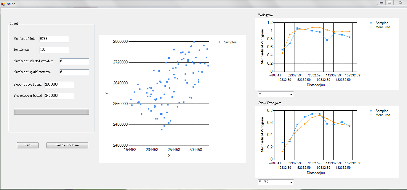
The Interface of scLHS
References for the tool:
Lin et al.
(2014)
An optimal spatial pre-sampling approach distribution of
bird species bases on various scale data. (preparing)
Lin, Y-P.,*,
W.-C. Lin, M.-Y. Li, Y.-Y. Chen, L.-C. Chiang, Y.-C.
Wang, 2014,
Identification of spatial distributions and
uncertainties of multiple heavy metal concentrations
by using spatial conditional Latin Hypercube
sampling. 230-231, 9-21. Geoderma.
Minasny, B. & McBratney, A.B. (2006) A conditioned
Latin hypercube method for sampling in the presence
of ancillary information. Computers & Geosciences,
32, 1378-1388.
This tool is mainly funded by Minister of Science and
Technology of Taiwan ( National Science Council of
Taiwan) (NSC101-2923-I-002-001-MY2), and a
contribution from the project SCALES: Securing the
Conservation of biodiversity across Administrative
Levels and spatial, temporal, and Ecological Scales,
under the European Union’s Framework Program 7 (grant
226852; www. scales-project.net; Henle et al. 2010).
Further version of NRT will be a contribution from the
project EU-BON.
|
|
National
Responsibility Tool (NRT):
National Responsibility
tool (NRT) is a GIS tool that can be used to evaluate
the national responsibilities concerning conservation
and the conservation priorities with respect to focal
species in a focal area on various scales, such as both
administrative and biophysical scales. Utilizing the
spatial analysis and geo-processing powers of a GIS, the
NRT tool performs three types of calculation - “by
area”, “by biome-area”, and “by biome” - that take into
account disturbances of bio-climates, species, and focal
areas across various scales. Additionally, the tool was
tested using 258 bird species and various biophysical
regions, including bio-climates and biomes in 38 Asian
countries. The tool improves the geoprocessing and
spatial analysis procedure for calculating a large
geodataset of data concerning NR and CP while
simultaneously analyzing National Responsibility (NR)
and Conservation Priority (CP) for multiple focal
species in many focal regions. The tool also provides
users with a friend and visual environment in which to
obtain efficiently NRs and CPs for focal species in
various regions across various scales, and allows users
to visualize, query, and analyze results concerning NR
and CP. (Lin et al. 2014)
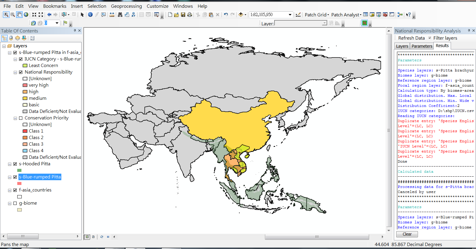
The Interface of NRT 1.0 (Lin et al. 2014)
Please contact Prof. Yu-Pin Lin at
yplin@ntu.edu.tw
(Coordinator of SCALES-Taiwan), Prof. Klaus Henle, Dr.
Dirk Schmeller, or Dr. Reinhard Klenke (main Coordinator
and coordinators of
SCALES project;
www.scales-project.net) for the current version of
NRT 1.0.
This tool is mainly funded by Minister of Science and
Technology of Taiwan ( National Science Council of
Taiwan) (NSC101-2923-I-002-001-MY2), and a
contribution from the project SCALES: Securing the
Conservation of biodiversity across Administrative
Levels and spatial, temporal, and Ecological Scales,
under the European Union’s Framework Program 7 (grant
226852; www. scales-project.net; Henle et al. 2010).
Further version of NRT will be a contribution from the
project EU-BON.
References for the tool:
Lin, Y.-P., Schmeller,
S.D., Ding, T.-S., Wang, Y.-C., Lien, W.-Y., Henle K.,
Klenke, R. (2014) A tool to determine national
responsibilities and priorities for species conservation
(Preparing).
Schmeller, S.D., D. Evans,
Y.-P. Lin, K. Henle, 2014, The national
responsibility approach to setting conservation
priorities - recommendations for its use. Journal of
Nature Conservation. (In press)
Schmeller D. S. , B. Gruber, B. Bauch,
K. Lanno, E. Budrys, V. Babij, R. Jukaitis, M. Sammul,
Z. Varga. and K. Henle, 2008a, Determination of national
conservation responsibilities for species conservation
in regions with multiple political jurisdictions.
Biodiversity and Conservation 17:3607 - 3622.
Schmeller D.S., B. Gruber, E. Budrys,
E. Framsted, S. Lengyel, K. Henle, 2008b, National
responsibilities in European species conservation: a
methodological review. Conservation Biology 22(3):593 -
601.
土壤重金屬污染潛勢決策軟體
由於進行土壤重金屬污染潛勢預測之步驟較為繁瑣,為便於後人參考使用,故本計畫將整合上述之研究方法,嵌入QGIS2.4.0
(http://www.qgis.org/en/site/)中運行。QGIS
2.4.0之最低硬體需求為1.6GHz之處理器以及1.0GB
RAM,作業系統環境為Windows
XP或更新之系統。在整合程式中的多變量地理統計模擬部分,使用R語言撰寫,根據高斯連續模擬與U-WEDGE法發展而成,可滿足使用者同時考慮多種重金屬的情況,來產生多組不同的土壤重金屬分布情境。在完成土壤重金屬分布情境模擬後,則可使用整合程式中的決策分析部分,同樣是使用R語言撰寫完成,主要是以information
gap theory (IGDT)為基礎來發展。可根據地理統計多變量模擬結果篩選出土壤重金屬污染潛勢較高的區域,便於後續採樣規劃。
軟體操作說明:軟體說明會.pdf
軟體下載:請先取得授權 eales2014 at gmail.com
|