|
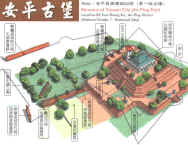
6. Square Fortresses in Taiwan |
||
|
|
||
|
1624 |
||
|
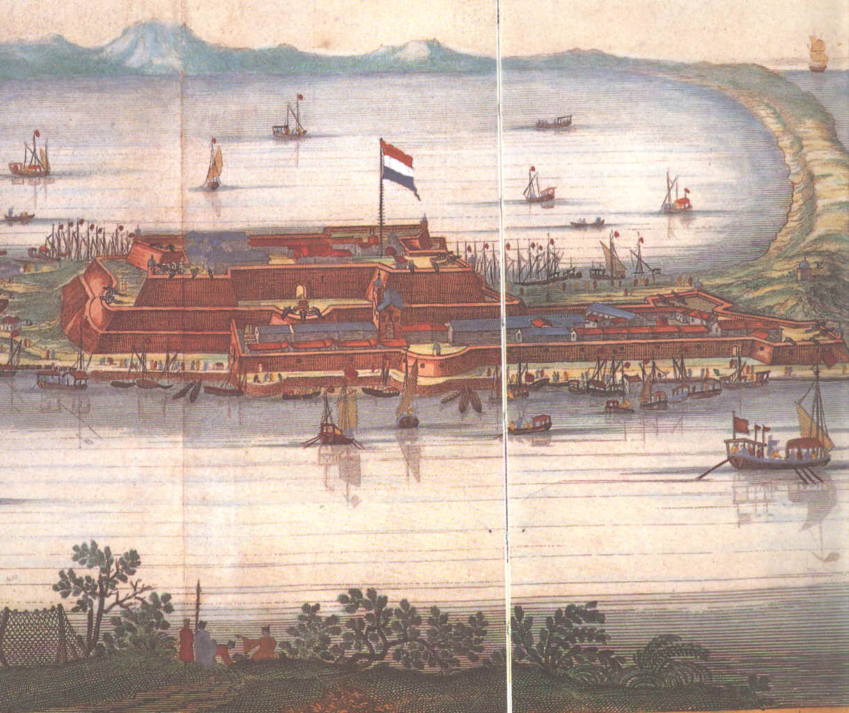
The fortress Zeelandia and her evolution |
||
 |
1626 | |
 |
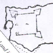
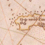
Anonymous and undated map | |
 |
||
 |
||
 |
||
 |
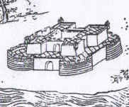
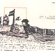
Dapper | |
 |
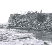
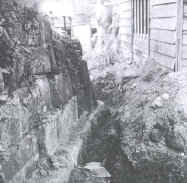
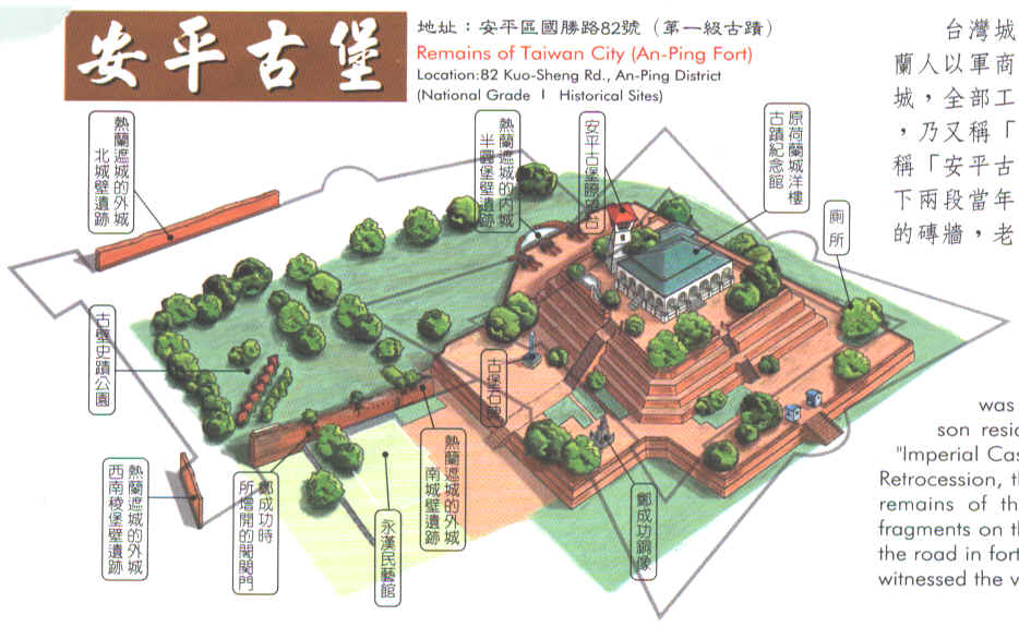
bigger size Picture taken from the ticket for entering the ruins of Anping fort |
|
|
|
2002 Click here to see the original. (Courtesy of the Department of Civil Engineering of Chengong University) |
Probably the first application in Taiwan of the Ground Penetrating Radar (GPR) system to archeological research was done in this fortress of Anping. The research was conducted by the team of Prof. Der-her Lee (李德河) from the Department of Civil Engineering of National Cheng-kung University (成功大學土木系). They were able to identify which parts of the underground structures of the castle were still existing. |
|
|
||
|
1626 |
||
|
The fortress Santísima Trinidad and her evolution |
||
|
|
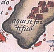
1626 |
The first news about this fortress come from the first year of the Spanish Period. They corroborate the information offered by Pedro de Vera’s map of 1626: "Aqui se fortifica" (Here fortifications are been made). So, the Spaniards started to build the fortress as soon as they reached the island. We think that the construction of the fortress was finished a few years before the final engagement with the Dutch in 1642. Thus, in those last years of Spanish presence, the bulk of the work consisted in demolishing the fort Santo Domingo in Tamsui and La Retirada, which was rebuilt shortly before the final battle. After which the fortress underwent a series of reconstruction and demolition, depending on the strategic requirements of the Island’s new masters. |
|
|
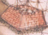
1629 |
By
1629, the construction was at an advanced stage, as stated in the report
made from the Dutch ship the Domburch.
This map, drawn by Gerbrantsz Black, shows a view of the fortress
from the said ship. One cannot make out whether the map shows just one
bastion or the “body” of the fortress. However, comparing the size of
these figures with that of the ship that was stationed behind it, as well
as with its other main parts, one can ascertain that the figure in
question represents the main bastion of San Antonio el Grande. We know that the engineer-planner who was in charge of
the construction was a man named Nicolás Bolem, whose
surname already belies that he was at least of Flemish or Dutch descent.
We can also know that the Chinese contribution to the building of
the fortress, because they either provided the materials or worked as hired brick
layers. |
|
|
1654 |
When the Dutch seized La Santísima Trinidad in 1642, the VOC destroyed three bastions and the walls between them, leaving only the bastion San Antonio el Grande intact to guard the entrance of Kelang Bay. The Dutch renamed this bastion Noord Holland. What remained of La Santísima Trinidad was used to build fortifications in Tamsui. The Dutch lived in this situation for 20 years (1642-1662) because, as they acquired greater control over Taiwan, they no longer saw the need to maintain a fortress that would defend them against external attack. Certainly, they enjoyed good relations with the English, and had successfully kept the Spaniards in Manila at bay. The Japanese had closed their doors to all foreigners and the Chinese had their own internal problems to solve on account of the Tartar invasion. This is why the map of Simon Keerdekoe (1654) clearly shows the then-current state of the fortress as well as how it looked during the Spanish period. But, finally, Kelang, was abandoned by the Dutch in 1661 out of fear of Koxinga. |
|
|
1664 |
The
Dutch attempted to regain again control of the China coast, and Kelang
was chosen
again for two
reasons: on the one hand, it was feasible to control shipping to
China and Japan, and on the other hand, it could serve as a springboard to
establish a new, flourishing trade factory. This “New Taiwan Factory”
would have to function as a relay station for Chinese sugar, gold, silk, etc.
Chinese merchants crossing the Taiwan straits were supposed to furnish
these goods in exchange for Japanese silver, and spices from the
Indonesian Archipelago or deer meat from Taiwan. The goods were to be
stored in warehouses, awaiting the favorable monsoon winds that would take
them to far-flung destinations all over Asia. The VOC envisioned the
“New Taiwan Factory” to be large-scale enterprise, which was why the
company had plans to invest a huge amount on improving the defense facilities in
Kelang. Still, trade never took off. |
|
|
1644 |
In 1664, the Batavian authorities instructed commander Balthasar Bort to reoccupy Kelang, to rebuild redoubt Victoria and to protect the bay’s entrance. If deemed necessary, he was ordered to rebuild La Santísima Trinidad using as much as possible its old foundations. On 20 August 1664, the yacht Niewendam appeared in Kelang. Commander Bort immediately set out to reconstruct the redoubt Victoria and then began working on the reconstruction of the other three bastions of the old fortress La Santísima Trinidad. Of utmost importance was the bastion Oosterpunt, also called the Half Moon Bastion, which was the eastern bastion. The northern bastion, called Zeeburg, protected the fortress from sea attack. The bastion Zuijderpunt, also called the Small Half Moon Bastion, was the southernmost bastion that controlled all shipping within the bay; its firepower could easily reach mainland Formosa. By the end of 1665, the bastions were up and in operation and La Santísima Trinidad had regained its old glory. The Dutch renamed it fortress Noord Holland. |
 |
1666 Cornelis Vichbee ARA VEL 307 |
On 4 February 1666 elders
of several aboriginal villages informed that 500 soldiers of Zheng’s troops
had reached Tamsui from Anping
by land and about 700 or 800 were already
stationed in Tamsui, and that 30 junks with more troop reinforcements were
expected to arrive two months later. To deal with
this threat, the VOC started to build extra fortifications. On 21 February
1666, the Council of Kelang resolved to start constructing a small redoubt
on the foundations of a former Spanish fortress (el Cubo). The small
redoubt was called Nobelenburg. As an invasion of Zheng’s troops became more and more evident,
the Kelang Council resolved on 17 April 1666 to further reinforce its
defenses. Orders were issued to raise the walls of Noord Holland, to build extra walls,
and to make gabions. Most of the straw roofs of the buildings in the
fortress were removed to diminish the risk of being set on fire. The Zheng
army landed on 11 May 1666 and launched a relentless attack on the
fortifications for several days. An estimated 6,000 Zheng soldiers partook
in the operation, engaging the 300 VOC defenders. After a siege of nine
days, the Zheng army, having about 1,000 wounded or dead (according to a
Dutch account), withdrew to Tamsui. The reconstructed fortress had passed
its first serious test. |
 |
1676 |
Redoubt Victoria was reinforced after the Zheng attack. The ruins of the former Spanish cloister were leveled to prevent the enemy from using it as a battery facility against the fortress. The bastion Oosterpunt (Half Moon Bastion or Bultenberg bastion) proved to be a weak spot in the entire defense system because it was built on sand and had no solid foundation. The walls of the bastion fell beneath the enemy’s artillery and even threatened to collapse when the Dutch fired their own cannons. So, the Dutch decided to reshape again the whole fortress following the original foundations.Bastion Oosterpunt had to be replaced with a new bastion (with a cellar) on the foundations of the former Spanish bastion. Stones from the said Spanish cloister were used as building material. Construction began on 13 December 1666 and the bastion was finished on 15 January 1667. |
 |
1676 |
Inside the fortress, a new smithy and a shop that also functioned as a dormitory were added. The cellar under bastion Noord-Holland was also expanded. Outside the fortress, a new hospital, a carpenter’s shed, and a pigsty were built. But, unexpectedly, on October 1668, the VOC garrison abandoned Kelang after blowing up the defense works. The other buildings were demolished, leaving nothing but a pile of rubble. |
 |
1696 |
The area was abandoned and hardly used by Chinese settlers. This is an ideal view of the castle that appeared published in 1696. When the "Macedonian" ship of Commodore Perry passed by Jilong in 1854, in his way to Japan he made a detailed map of the area with a reference to the ruins of Kelang castle. The same happened in 1884, during the French invasion. In the book of Captain Garnot appeared a reference to the ruins of the castle, as a "Vieux Fort". We have to wait to Japanese for new relevant information. |
 |
1920 |
The other side of the problem is the development of Jilong Harbor, the third phase of which, according to Ms. Lu Yueh-E dissertation on the topic, took place from 1929 to 1934. The new expansion happened because of the increasing scale of trade and fishery. She Liao Tao was remodeled to accommodate in its southern side the fishing port that was previously located in the inner harbor; this inner harbor was no longer used for simultaneous business and fishing activities. In addition, the Japanese government began to “feather-bed” the fisheries industry by providing equipment and social benefits. At that time, the ruins of San Salvador were not threatened by the new reforms and the development of the harbor; in fact, the new legislation expressly provided for the protection of this historical spot. |
|
1936 |
Scholars
began to get involved in the matter. In November 1931, Prof. Murakami
Naojirō of Taihoku University published a long article on the history
of the fortress, based in Dutch sources. At the end of the article he
mentioned that the southwestern bastion was still standing. Soon later, in
July 1932, the Bureau for Internal Affairs of the colonial Government
published a cyclostyle pamphlet entitled Report on Designated
Historical Sites. In Chapter 2 of this work, Prof. Murakami Naojirō
repeated his former ideas, mentioning that even Zheng Jing attempted a
reconstruction in 1673 and installed there a garrison of soldiers.
Murakami concluded: “Because this construction dates back to the San
Salvador castle’s times, it is worth to be preserved for ever”.
He ended the article quoting briefly from Osaki and Ite’s 1931
report. |
|
1937 |
Finally, at the beginning of October 1936, the Office started to pre-pare for the diggings. A chronological account of the project is recorded in the journal of the Institute. Days 9, 12 and 15 of the preparatory phase were presided by Prof. Utsurikawa Nenozo and probably by Prof. Murakami Naojirō himself. Actual fieldwork started on Day 19, under Prof. Iwao Seiichi, Miyamoto Nobuto, Matsumnoto Masanaga, and Nakamura Takashi. |
|
1937 |
The
team hired the services of famous Japanese photographer Kobayagawa
Tokushirou,
who produced a comprehensive hundred-photo collection of the excavation.
This may be the same one preserved in the Museum of Anthropology of
National Taiwan University. Selected photos from this collection are
published for the first time in this book. |
|
1937 |
The excavation team measured the castle’s remaining walls and they photographed any interesting thing, like some parts of bastion San Antonio el Grande. But their main job was to clean the northeastern bastion, and to unearth its inner cellar, and outer cellar, where they found other foundation that had nothing to do with the Dutch castle. Their scholarly report on the job using the measurements taken from the castle and all their findings remains unedited until now. The only known report of the entire project was a brief account that was published a few months later in the miscellaneous section of the journal of the Institute. |
|
1937 |
Thus remains a series of unanswered questions. For example, we do not know precisely when the plans to remodel the area of the castle started. Neither do we know the real interest behind the Jilong government’s request to the Taihoku University, or the political motives of the other institutions involved in it. Did the Governor General withdraw abruptly the castle from the list of protected monuments? Was the Jilong government aware of what was going to happen to the fortress and so proposed the excavation as the only way to “preserve” it? Neither do we know if the members of the archeological expedition knew of such a “conspiracy”. We can only guess that all these events that happened at the same time are sort of interconnected. |
|
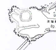
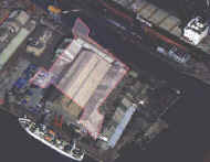
2000 |
This picture represents ideally the possible location of the old fortress under the modern warehouses. According to this restitution, one of the bastions have disappeared because of the construction of a dry dock in 1937. Other one might be under a parking space, while the rest of the foundations of the fortress might be preserved under a warehouse. |
|
|
||

